QGIS project and tools#
Administration project#
The algorithm Create database local interface creates a QGIS administration project with the layers of all the tables of the database, and the actions needed to manage the network.
The project contains the following groups of layers:
AEP: the drinking water network, schemasstareau_aepandstareau_aep_brcht: pipes, service connections, water intakes, treatment plants, reservoirs, valves, pumping stations, etc.,ASS: the sanitation network, schemasstareau_assandstareau_ass_brcht: pipes, service connections, manholes, outlets, basins, pumping stations, collection points, etc.,Commun: the shared objects of the schemastareau_commun: geolocation points, rain gauges, piezometers, and the fire water pointspei,Valeurs: the value lists of the schemastareau_valeur,Bases: the parent tables of the schemastareau_principale:noeud_reseau: all the network nodes, of all the networks,canalisation: all the pipes, of all the networks,emprise: the footprints.
The layers of the group Bases show the objects of all their child tables
(see Table inheritance).
To create a new object, use the layer of its specific table, for example aep_vanne for a valve
or ass_canalisation for a sanitation pipe.
Panel and menu#
Administration panel#
The panel StarEau is used by the administrator to install and configure the database, and to run the tools of the plugin:
- the group
Informationshows the PostgreSQL connection used by the project, the versions of the plugin and of the database structure, and checks that they match:The database is OK: nothing to do,The database version is older than your plugin version: run the algorithm Upgrade database structure,The required schema version is older than the database structure version: upgrade the plugin,
- the group
Install and configureruns the algorithmsConfigure plugin(buttonChoose database connection),Create database structure,Create database local interfaceandUpgrade database structure, - the group
Toolsruns the algorithms which check and analyse the network:Get missing nodes,Get orphan nodes,Get duplicate nodes,Fill AEP vertices and edges,Treatments to nearest reservoirandWater intake points to nearest treatment, - the group
Helpopens this documentation.
The buttons are disabled, except Choose database connection, while the project has no valid
database connection: run the algorithm Configure plugin first.
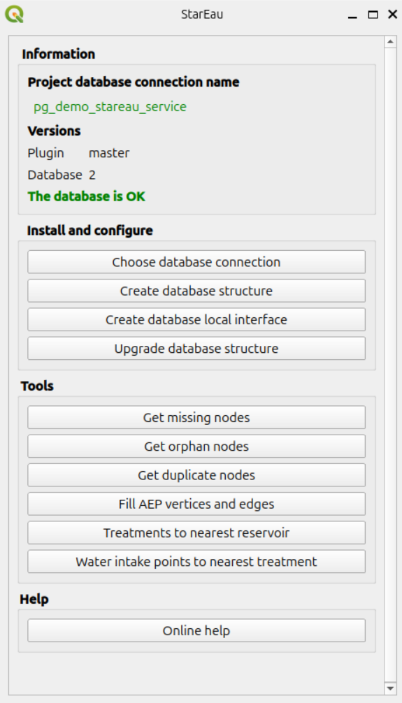
See Processing algorithms for the description of these algorithms.
Menu#
The menu Help / Plugins / StarEau opens this documentation.
Layer actions#
Some layers of the administration project have actions, run by the StarEau plugin, which must be installed and activated:
| Layers | Action | Usage |
|---|---|---|
canalisation, aep_canalisation, aep_canalisation_branchement, ass_canalisation, ass_canalisation_branchement |
Inverser la canalisation | Reverse the direction of the pipe |
aep_vanne |
Fermer la vanne | Close the valve |
aep_vanne |
Ouvrir la vanne | Open the valve |
aep_captage, aep_vanne |
Chercher traitement | Show the pipes to the nearest treatment plant |
aep_traitement, aep_reservoir, aep_vanne |
Chercher reservoir | Show the pipes to the nearest reservoir |
aep_traitement, aep_vanne |
Chercher captage | Show the pipes to the nearest water intake |
ASS node layers: ass_regard, ass_pompage, ass_bassin, ass_exutoire, ass_traitement, ass_pretraitement, ass_piece, ass_raccord, ass_point_collecte, ass_engouffrement_point, ass_ouvrage_special_point, ass_chambre_depollution |
Downstream | Show the pipes downstream of the node |
| same ASS node layers | Upstream | Show the pipes upstream of the node |
To run an action on a feature, use the Identify Features tool and right-click on the feature in the map,
or use the Run Feature Action tool of the Attributes toolbar.
The Python code of these actions is stored in the plugin: the actions of the project only call it, for example:
1 2 3 4 5 6 7 | |
The same code can be used to add the actions to the layers of another QGIS project.
The action must be of type Python. The layer must be a PostgreSQL layer of a StaR'Eau table:
the actions check the geometry type and the fields of the layer, and display an error message in the
QGIS message bar if the layer is not valid.
Reverse a pipe#
Action inverser_canalisation: reverses the direction of the line of the pipe.
Parameters: fid_canalisation (the fid of the pipe) and id_layer (a line layer).
The trigger functions of the database then update the initial and terminal nodes of the pipe, see Network topology. Use it when a pipe has been drawn in the wrong direction, for example against the flow direction of a sanitation network.
Close or open a valve#
Actions fermer_vanne and ouvrir_vanne: set the field etat_ouverture of the valve
to fermee (closed) or ouverte (open).
Parameters: fid_vanne (the fid of the valve) and id_layer (a point layer with the field etat_ouverture).
The closed valves are used by the network analysis functions which avoid closed valves.
Path to the nearest target#
Action aep_pgr_path_to_nearest_target: walks the drinking water network from the clicked node,
and adds to the project a layer path_to_<target_table> with the pipes between the node
and the nearest target: water intake, treatment plant or reservoir.
Parameters:
fid_noeud: thefidof the node,id_layer: a point layer of a drinking water node table,target_table: the table of the targets, starting withaep_, e.g.aep_traitement,aep_reservoiroraep_captage,avoiding_closed_valves:FalseorTrue. IfTrue, the closed valves cannot be crossed.
1 2 3 4 5 6 7 8 9 | |
Note
All the parameters of an action must be given in the action code, even the ones with a default value
in the Python function: otherwise the error Arguments invalides is displayed.
The message Aucun chemin n'a été trouvé pour atteindre la cible is displayed if no path is found.
This action needs pgRouting and an up to date routing graph: run the algorithm Fill AEP vertices and edges after editing the drinking water network. See Network analysis.
Upstream and downstream of a sanitation node#
Actions ass_downstream and ass_upstream: walk the sanitation network from the clicked node,
following the direction of the pipes, and add to the project a layer Downstream or Upstream
with all the pipes located downstream or upstream of the node.
Parameters: id_noeud (the id_noeud_reseau of the node) and id_layer (a point layer with the field id_noeud_reseau).
The walk stops at the pipes whose initial or terminal node is missing (non_renseigne).
These actions do not need pgRouting.
Nearest valves#
Action aep_pgr_nearest_vannes: finds the valves to close to isolate a point of a drinking water pipe,
and adds them to the project in a layer vannes_trouvées.
This action is not configured in the administration project, but it can be added on a pipe layer,
for example with the coordinates of the click on the map (action scope Canvas):
1 2 3 4 5 6 7 8 9 | |
Parameters:
id_layer: a line layer of drinking water pipes,point_x,point_y: the coordinates of the point, inEPSG:2154,closed_valves_only:FalseorTrue. IfTrue, only the closed valves are searched, and the open valves can be crossed.
See Nearest valves for the details of the calculation.